
Shoal Point
Beach Information
Beach Information
- 🏖️ Best Time to Visit: May to October for mild, dry weather.
- 🐠 Marine Stingers: Present November–May; no stinger nets.
- 🚩 Lifeguard Patrol: Not patrolled.
- 🐕 Dog Friendly: Yes (see Dog-Friendly Rules below)
- 🛠️ Facilities: Picnic areas, BBQs, parking.
- ♿ Accessibility: Limited wheelchair access.
- 🐊 Wildlife Awareness: Crocodiles possible in nearby waterways/estuaries. Be Crocwise. Deadly snakes extremely rare.
- 📍 Distance to Brisbane: Approx. 940–970 km (about 11–12 hours drive).
- 🏘️ Closest Town: Mackay — Distance: 21 km
- ✈️ Closest Airport: Mackay Airport — Distance: 29 km
- 🌦️ Typical Weather: Tropical; hot, humid summers, warm dry winters.
For the latest official beach conditions and safety information, check Beachsafe.
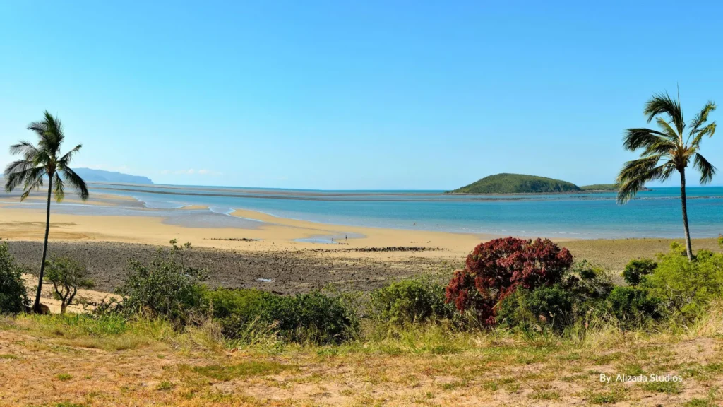
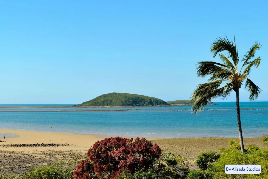
Shoal Point Mackay is the northern end of the Mackay coastal strip, with huge low-tide flats toward Green Island, soldier crabs Shoal Point on the exposed sand, Shoal Point Park on OBrien Esplanade, and Shoal Point fishing from the gutters, rocks and Hodges Road ramp.
🏝️Why Visit Shoal Point Mackay?
Shoal Point Mackay is the northern end of the coastal strip, with huge low-tide flats, soldier crabs Shoal Point on the wet sand, Shoal Point Park on OBrien Esplanade, and Shoal Point fishing from the gutters, rocks and Hodges Road ramp. Come for the low-tide walk, the park picnic and the line in the water, not for flags or a crowd.
🦀 Things to Do at Shoal Point
🦀 Soldier crabs — Low tide on the wet flats. Walk quietly
🌅 Sunset — Esplanade and Shoal Point Park look back across the flats
🎣 Shoal Point fishing — Sand gutters, rocks and the Hodges Road ramp
🚤 Boat launch — Hodges Park ramp on Hodges Road, or off the beach when the tide allows
🚶 Low-tide walk — Wide flats toward the island view. Turn back before the flood
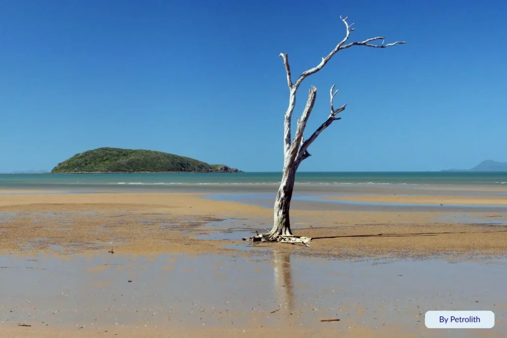
📸 Lone tree — Northern-end photo spot. Stay off the dune plants
🧺 Park picnic — Shade, BBQs and playground at Shoal Point Park
🎣Shoal Point Fishing
🎣 From the sand — Whiting, flathead and bream in the gutters on a falling tide
🪨 Point and edges — Queenfish and small trevally when bait pushes along the pressure line
🚤 Hodges Park ramp — Formal launch on Hodges Road. Not the picnic lawn on OBrien Esplanade
🦀 Estuary crabbing — Launch and work nearby creeks. Do not treat the bathing flats as a pot line
⚖️ Rules — Size and bag limits apply
⚠️ Tide — The flat floods fast. Do not wade toward the island
🌳 Shoal Point Park
📍 OBrien Esplanade — Paperbarks, lawn, playground, BBQs, toilets and the main parking
🛝 Playground — Stays open during the access-ramp works
🍖 Picnic — Tables, shade and free barbecues
♿ All-abilities ramp — Council is replacing the old timber beach access. Due mid September. Check the path on the day
🅿️ Park here first — Coach and car parks sit with the amenities
🚫 Ramp is separate — Trailers belong at Hodges Park on Hodges Road
🦀Soldier Crabs Shoal Point
🦀 Low tide only — Blue soldier crabs on the wet sand, then they vanish into holes
📷 Watch do not chase — Stay light on the flats
🌳 Lone tree — Northern end. Keep off the dune vegetation
🌊 Turn around on a making tide — The desert look is low tide only
🏊♂️ Swimming & Beach Safety
🚫 Unpatrolled — No flags. Beachsafe spit about 1.5 km, hazard 1/10
🌊 Huge tide — Flats run hundreds of metres then cover fast
🚫 Do not walk to the island — Green Island is offshore. The close view is a low-tide trick, not a crossing
🪼 Stinger season — November to May. No nets
🐊 Crocodiles — Listed on Beachsafe. Creeks, mangrove edges, dawn and dusk
⚠️ Soft sand and channels — Do not commit to a long out-and-back without a tide plan
🐶 Dog-Friendly Rules
🦮 On-leash only — Shoal Point sand, paths and Shoal Point Park
🚫 Not an off-leash beach — Signed off-leash sand is Bucasia, Williams Avenue to Symons Avenue, 5am to 8am and 5pm to 8pm
🌳 Estate park is not the beach — Shoal Point Waters Park on Beachway Boulevard is a separate lake park. Read the signs there. It does not change the on-leash beach rule
🗑️ Pick up — Mackay Regional Council rules apply
🏕️ Camping Near Shoal Point
🚫 No free sand camping — No overnight vehicles on the beach or dunes
🚐 Nearest paid parks — BIG4 Mackay Blacks Beach Holiday Park and other Northern Beaches parks
🏡 Town options — Central Tourist Park Mackay and Mycow Bakers Creek
🏕️ Further north — Seaforth Camping Reserve is council-run. Dogs only where signed
🛠️Facilities & Accessibility
🅿️ Parking — Shoal Point Park and OBrien Esplanade
🍖 BBQs, shade, playground, toilets — All at Shoal Point Park
🚤 Hodges Park boat ramp — Hodges Road
♿ Beach access — New all-abilities ramp due mid September. Confirm before you go
🍽️ No cafe on this park — Bring food or drive to Bucasia or Eimeo
🌤️Best Time to Visit Shoal Point
🦀 Low tide — Soldier crabs Shoal Point and the wide flats only exist then
🎣 May to October — Drier days for walks and Shoal Point fishing
🪼 November to May — Stingers. No nets and no flags
🌅 Late afternoon — Sunset from Shoal Point Park
🗺️ Getting There and Parking
🚗 Drive — About 25 minutes north of Mackay city via Mackay Bucasia Road and Shoal Point Road. Sealed
🅿️ Park at Shoal Point Park — OBrien Esplanade
🚤 Trailers — Hodges Park, Hodges Road
🚌 Bus is limited — Self-drive is what most visitors do
🚫 No 4WD on this beach — Informal dune tracks are blocked
🚧 Check the beach ramp — Access works at the park run into mid September
💡 Local Tips
🦀 Time the tide first — No low tide means no crabs and no desert flat
🌳 Start at Shoal Point Park — Toilets and shade before you walk
🚫 Do not walk to Green Island — Look at it. Do not treat the flats as a causeway
🍽️ Eat in Bucasia or Eimeo — Eimeo Pacific Hotel is the closest sit-down option
📸 Lone tree is at the northern end — Stay on the sand, not the plants
📍Nearby Attractions
🏖️ Bucasia Beach (immediately south)
🏖️ Eimeo Beach and the historic Eimeo Hotel
🏝️ Green Island / Green Reef Island views
🦘 Cape Hillsborough National Park (short drive north for kangaroo beach sunrises)
📅 Events & Markets Nearby
🛍️ Mackay Riverside Markets — Thursdays
🌿 Greater Whitsunday Farmers Market — Wednesdays
🍯 Mackay Showgrounds Markets — Most Saturdays
For a full list of what’s on in the region, visit the
👉 Mackay Attractions | Best Things to Do Near Mackay Beaches
🏕️Accommodation Near Shoal Point
🏡 Holiday houses — Shoal Point streets behind the esplanade
🏨 Mackay motels — About 20 to 25 km south 🚐 Blacks Beach and Bucasia parks — Paid stays. No camping on this sand
📖 Read Accommodation Reviews
📸 Submit Your Accommodation Review
💡 Please note: Full names and emails are kept private — only your chosen Display Name will appear publicly with your review.
🍴 Places to Eat & Drink
Shoal Point offers a peaceful coastal escape with a small selection of nearby cafés and takeaway spots in the northern beaches area of Mackay. Enjoy coffee or breakfast with ocean views, a relaxed picnic by the sand, or head to Bucasia or Eimeo for more dining options — then share your favourite food and drink experiences below!
📖 Read Food & Drinks Reviews
📸 Submit Your Food & Drinks Review
💡 Please note: Full names and emails are kept private — only your chosen Display Name will appear publicly with your review.
🧭Plan Your Trip to Shoal Point
Shoal Point is the perfect destination for those who enjoy nature, quiet coastal landscapes, and family-friendly facilities. From exploring tidal flats and crabbing at low tide to relaxing with a beachside BBQ while watching the sun dip into the horizon, Shoal Point delivers a true Mackay beach escape. Just a short drive from the city, it’s a must-visit spot on Queensland’s Northern Beaches.
💬 Share Your Shoal Point Beach Photos & Reviews
📸 We’d love to see your favourite moments from the Mackay Region! Upload your photos, share your experiences, and leave a review to help other visitors discover the pristine coastline, tropical islands, and hidden gems that make Mackay so special.
📖 Read Beach Reviews
📸 Submit Your Review
💡 Please note: Full names and emails are kept private — only your chosen Display Name will appear publicly.
💙 Explore More Beaches Nearby
Discover more of the Mackay Region:
Eimeo Beach ➜ | Bucasia Beach ➜ | Blacks Beach ➜ | Lamberts Beach ➜
🌊 About This Beach Directory
🌴 Note: This directory doesn’t include every beach in Queensland — there are simply too many! We’ve selected the most significant and unique beaches based on a range of factors including natural beauty, accessibility, and local popularity.
💌 If you think we’ve missed one that deserves to be featured, we’d love to hear from you!
📧 Email us at Admin@QldBeach.com with your photos and tell us why your favourite beach should be added.
☀️ Happy surfing, swimming and sunning from the Queensland Beach Guide team!
✅ Queensland Beach Guide contains affiliate links. This means if you click on certain links and make a purchase, we may earn a small commission at no extra cost to you. We only recommend products and services we genuinely believe will help our readers. All opinions are our own.
Last updated: June 2026
Shoal Point FAQs
Is Shoal Point patrolled?
No. Shoal Point is unpatrolled. Swim with caution, be aware of tides and marine hazards, and never swim alone.
Is there a boat ramp at Shoal Point?
Yes. A public boat ramp is located at the northern end of O’Brien Esplanade, allowing boats to be launched straight off the beach with easy access to nearby estuaries.
Can you see soldier crabs at Shoal Point?
Low tide on the exposed flats. Walk quietly. Do not chase or crush them.
Is camping allowed at Shoal Point?
No free or beach camping is permitted on the foreshore. The nearest caravan parks and holiday parks are in the broader Mackay Northern Beaches area (including Blacks Beach).
When are marine stingers present?
Tropical marine stingers (including box jellyfish and Irukandji) can occur from November to May. Bluebottles are possible year-round. Wear a stinger suit in season.
Can I walk to Green Island?
No. The island is offshore. At low tide the flats look close. Do not treat it as a wade-across. That is not what normal visitors do.